DockingMap is not a management software but a SaaS add-on to complement your existing tools.
Watch the video that explains what DockingMap really is.
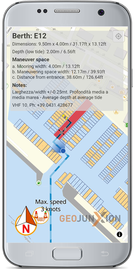
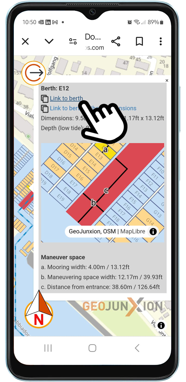
Thanks to DockingMap, the Marina has a super-easy tool to communicate all necessary information about the berth location with dimensions and related maneuvering spaces to the Skipper.
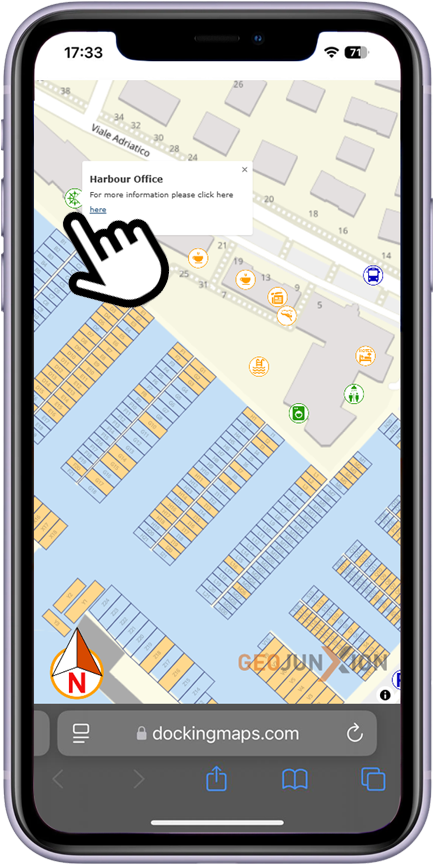
The Skipper does not need to log in or download anything to access the map!
DockingMap reduces the Skipper's stress during their first arrival at the Marina, decreases staff workload, and minimizes risks for both people and boats during docking.
DockingMap provides the Marina with a digital, georeferenced, and interactive map of the entire port area and its surroundings, navigable using GPS on tablets and smartphones.
This enhances the user experience at the port and promotes the port's services and its business partners (Shops, Restaurants, Hotels, Chandleries etc…).
DockingMap is an innovative SaaS solution — truly one of a kind — that seamlessly complements existing Marina software, instantly enhancing port-to-Skipper communication procedures.
There are no integration costs, and the system is ready to use immediately after the set-up.
This makes DockingMap an ideal solution for Marinas looking to modernize their operations without the financial and technical barriers often associated with new technology.
By choosing DockingMap, Marinas can enjoy the benefits of automation while avoiding disruptions to their existing workflows.
Enhance your management system!
DockingMap empowers Marinas to embrace sustainability by reducing emissions, minimizing waste, and streamlining operations. Through precise navigation tools, Marinas cut fuel use and promote eco-friendly practices.
Interactive maps educate visitors on recycling points, eco-friendly amenities, and local attractions, encouraging sustainable behaviors and creating a shared commitment to environmental protection.
By automating communications and reducing errors, DockingMap enhances efficiency, protects resources, and makes sustainability accessible to Marinas of all sizes.
One single Link to share all info!
“Following the current procedures, with their smartphone, one click to select the berth assigned to the arriving boat and another click to copy the link to send to the Skipper.”
“Without Login or Download, one click to open the link sent by the Marina and view the route to the assigned berth directly in the device's browser, complete with all the docking details they need.”
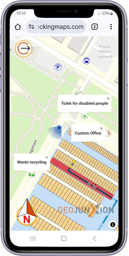
“Thanks to the interactive and georeferenced digital map on the Marina's website, they can see their GPS location and find the easiest routes to services and points of interest.”
DockingMap is not a management software but a SaaS add-on to complement your existing tools.
Watch the video that explains what DockingMap really is.
DockingMap is an easy-to-use tool to communicate crucial information to Skippers: berth locations, dimensions, and maneuvering spaces in two clicks.
The system minimizes staff workload by automating the sharing of berth information, allowing Marina staff to focus on other tasks.
DockingMap reduces the Skipper's stress by providing clear docking instructions, particularly during their first arrival. This makes docking smoother and safer.
The platform includes a georeferenced and interactive digital map, navigable via GPS on smartphones and tablets, enhancing the user experience and promoting Marina services on its website.
DockingMap provides clear docking instructions, helping Skippers reduce the risk of accidents or errors during mooring, thereby protecting both people and boats.
DockingMap enhances sustainability by streamlining communication, cutting fuel consumption, reducing maneuvering impacts, and eliminating paper use.
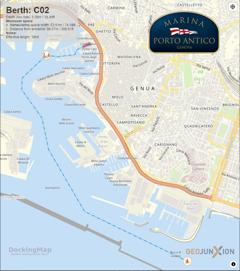
Marina di Porto Antico is a prestigious Marina located within the commercial port of Genoa, where strict regulations set by the port authority govern navigation to the Marina. To meet these requirements, the Marina must communicate with its clients in a straightforward and effective way. DockingMap provides the ideal solution, offering a secure and practical tool for Skippers to receive clear guidance on the route to the Marina and detailed information about their assigned berth and its specific characteristics, including maneuverinf spaces.
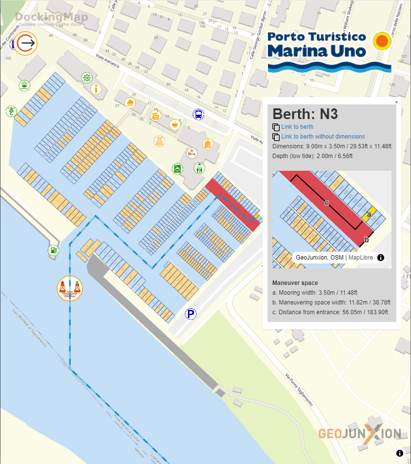
Marina Uno, the first tourist Marina on the Friulian coast, is accessed via the mouth of the Tagliamento River. The need to optimize docking operations stems from the challenge of coordinating dockside staff with the transit timing of vessels navigating the river. Additionally, the Marina directly manages only a portion of the berths within the port, requiring precise communication to Skippers to avoid confusion and unnecessary delays. DockingMap offers a streamlined approach to address these challenges, ensuring smooth coordination and a seamless docking experience.
DockingMap is not a management software but a SaaS add-on to complement your existing tools.
Watch the video that explains what DockingMap really is.
Up to 5 adjacent berths
The easy way to test DockingMap
Up to 300 berths
DockingMap + Marina Map
Capital Expenditure
Intellectual Property

DockingMap goes beyond berth management by offering an interactive Last Mile Map. This feature geolocates key event areas, exhibitors, and services, accessible via an easy-to-embed iFrame on the event website.Integrated with GPS, it offers wayfinding functionality tailored to diverse accessibility needs. As a sustainability-focused SaaS solution, DockingMap eliminates paper-based navigation aids...
Read the Article >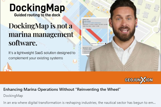
DockingMap by GeoJunxion simplifies Marina operations by enhancing last-mile navigation for Skippers through georeferenced maps and real-time instructions. This lightweight, standalone SaaS tool improves efficiency, reduces stress, and supports sustainability without disrupting existing workflows, transforming Marina management into a seamless, user-focused experience...
Read the Article >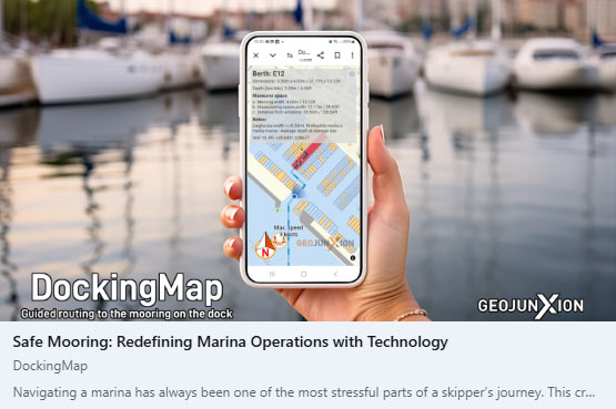
DockingMap introduces a user-friendly, browser-based solution that enhances marina operations by providing skippers with precise docking instructions without the need for app downloads or logins. This streamlined approach improves communication between marina staff and skippers, ensuring a seamless and efficient docking experience. By integrating DockingMap into their services...
Read the Article >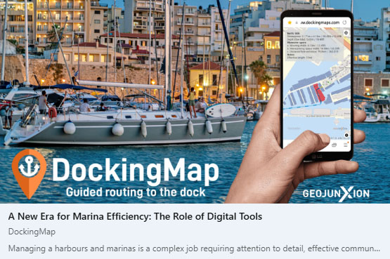
DockingMap simplifies Marina operations by automating berth communication, saving time, reducing errors, and enhancing service quality. Its user-friendly SaaS platform requires no costly integration, providing seamless adoption for Marinas of all sizes. By streamlining processes, DockingMap boosts efficiency, fosters Skipper satisfaction, and positions Marinas as forward-thinking, tech-savvy hubs...
Read the Article >
Dive into our updated collection of LinkedIn articles, where we explore the "why" behind DockingMap and its unique role in the maritime industry. These articles shed light on how DockingMap bridges critical gaps in marina operations, enhancing skipper experiences without replacing traditional navigation tools.
Understand how DockingMap complements existing systems, offering a seamless and innovative SaaS solution to transform the last-mile docking process. Whether you're curious about its main functions or its strategic position as an add-on, this resource is your gateway to understanding the value DockingMap brings to marinas and their users.
DockingMap offers Marinas the ability to capitalize on digital transformation through CAPEX. By providing a perpetual license and ownership of a Marina's "Digital Twin," DockingMap enables long-term asset management. This solution allows initial digitization costs to be amortized, aligning with international accounting standards, while enhancing efficiency and sustainability.
DockingMap Digital Twin IP
DockingMap is an innovative SaaS tool revolutionizing Marina operations by providing interactive, georeferenced maps and seamless docking guidance. With no integration costs, it enhances efficiency, reduces Skipper stress, and improves user experience, making Marinas safer, more sustainable, and technologically advanced. Its simplicity and adaptability make it a transformative solution for ports.
DockingMap Quick Presentation
DockingMap simplifies Marina operations with an intuitive, integration-free SaaS solution. Staff can manage docking via two clicks only, and Skippers receive essential navigation details instantly through a single link, no downloads or logins required. This user-friendly approach ensures seamless, efficient, and stress-free management for Marinas of all sizes.
DockingMap How It Works
DockingMap is not a management software but a SaaS add-on to complement your existing tools.
Watch the video that explains what DockingMap really is.